SWEDEN: Bergslagsleden Stage 8
Mogetorp – Blankhult 16 km

Windbreaks in Vinterhagen.

Rusakulan
Height:
17 kmEstimated time:
4.5 hoursSurface:
Level changes - considering redwoods and forest road.
The stage starts at Mogetorp, located on Highway 50 where it goes daily frequent buses. Near the starting point is the first stage attraction: a large wolf pit, which in ancient times used to catch wolves and other predators in.
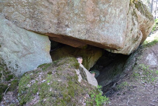
Mogetorp is one of the gateways to Skärmarbodabergen Bergen block cave area. In omårdet are several trails that take visitors on a tour of boulders, large caves and breakneck passages. Path system is highlighted in yellow, but if you go Bergslagsleden you should stick to the orange markings.
few kilometers go leg of soft, easy trails through sparse pine forests. It thrives birds nightjar, Redstart and Spotted Flycatcher. During winter, it is often only tofsmesarnas cooing is heard from the trees. When you go on stage, paths, it is hard to imagine that just a few kilometers away there Skärmarbodabergen Bergen block cave area, where much of the ice age ended and the material formed a delta of sand and occasional kettle holes.
few kilometers go leg of soft, easy trails through sparse pine forests. It thrives birds nightjar, Redstart and Spotted Flycatcher. During winter, it is often only tofsmesarnas cooing is heard from the trees. When you go on stage, paths, it is hard to imagine that just a few kilometers away there Skärmarbodabergen Bergen block cave area, where much of the ice age ended and the material formed a delta of sand and occasional kettle holes.
Higher forest
After a couple of kilometers becomes pines higher and you walk into a pillared hall before the path leading down into a small ravine, where the little Ranglabäcken slowly works its way on its journey down to Närkeslätten.
After 2.8 km departs the Circle Trail, which runs until Rökärrsstugan , from stage 8 and leads back to Mogetorp on Stage 7. Rökärrsstugan is a small rest cabin that is always open to hikers. If you want to wander round the loop is 5 km back to Mogetorp.
few hundred meters later you will arrive at a 175 meter long looping trail that leads to the Blue Grotto, which is a known block cave that you can go in for.Here the turnoff is a sign describing the block caves and Skärmarbodabergen.The trail passes over a large charcoal kiln, whose circular shape it is still easy to see clear traces of.
A few hundred yards later, another looping to block cave Freedom Portal, which is a monumental block cave with over fifteen feet wide opening. Dead-end trail is 400 meters long.

If you are lucky you can see Berguven.
Amboberget looms
After about 4 km hike fades the mighty Amboberget up on the right side. A kilometer later turns round loop Amboberget from Bergslagsleden and you have 6 km to go if you decide to go back to Mogetorp on round the loop. From Amboberget you have a magnificent view to the east. The landscape is varied with a mixture of large forests, gullies and swamps.
now trail goes uphill and the scenery changes shape. Pine and spruce of replacing just peeping Liaberget on the left side. At its summit are large deciduous stands, especially of birch. The climb continues up towards Liaberget, where hikers are treated to great views and a lovely bench to meditate on before the hike continues.
Bergslagsleden balance here on the mighty Kilsbergsförkastningen and in a couple of kilometers peeping all the time the wide plain, which is far below you .It's a nice walk through mixed forest with large deciduous trees.

Vinterhagen
Rest Vinterhagen
The last stretch to the rest area at Vinterhagen, go through and over the rubble, which was formed when Yoldia Sea waves took off all the way from Russia surged over Kilsbergskanten. Sand and gravel was cool down and made himself comfortable on what is today Närkeslätten. Above these surged surfaces never got the sea and it is called HK, Supreme coastline. In this högstammiga birch thrives göktytan, whose characteristic whining sound you can hear in the beginning of May.
Picnic Vinterhagen, is perhaps one of the most beautiful Bergslagen trail. It is located at the edge of the forest, and before him, the nyröjda claiming pastures, located in the old shingle.
These hazel groves are Närkes county animal Dormice, unfortunately, however, too difficult to find. In sydbranten thrive hepatica and a variety of other flowers.300 meters from the shelter is a spring for drinking water. Rest area is 175 meters, compared to the start at Mogetorp located approximately 50 meters above sea level.
The hike continues
After the well-deserved rest will trek through the hazel groves, where hepatica and wood anemones lining the trail during April and May. The walk over large parts of the old tracks, where Kilsbergsborna in times past was traveling on foot or horseback.
The forest consists of fine mixed forest with some birch, aspen and other hardwoods. The trail continues to balance on Kilsbergskanten and it makes you often can sense plain and the city Örebro among the trees far off in the distance.
Rusakulan
After just over 2 km hike will take you to a crossroad that leads up to Rusakulan 300 meters away. Rusakulan is one of Kilsbergen prime vantage points, situated 265 meters above sea level. On a clear day, a large part of Narke in front of your feet. With binoculars, you can then see a radar tower in Godegård, Östergötland, 75 km away. You can also see the silo buildings in Norrköping harbor, 58 km from here. Before flushing, you can count to over 20 church towers. At Rusakulan also shelter with a fireplace and a dry toilet. This turn-off, you should also check if you walk round loop Blankhult.

Large clocks the cab lake
After a few hundred meters glimpsed Little Klockar Cabin Lake, which is possibly even less than its big sibling. Here is another crossroads, where Bergslagsleden going one way and round loop Blankhult turn towards Skrikarboda.
The trail now continues into the Northern Magic Valley, where another crossroads there. Bergslagsleden follow the wonderfully beautiful and worth seeing Trolldalen, while circular trail Blankhult take a shortcut to Blankhult.

Waterfalls in the Magic Valley.
Kilsbergen Magic Valleys
Kilsbergskanten is a fault escarpment that formed 250 million years ago, during the geological era called perm. In the context of mountain building in southern Europe occurred even in our region stresses in the crust, resulting in cracks.
Fault cliff formed by the ground on each side of the crack shifted vertically so that a kind of steps occurred. Perpendicular to the big Kilsbergsförkastningen are several ravines, of which the Northern Trolldalen is one of the most powerful, with height differences in the slopes of close to 100 meters. The cracking occurred already when Kilsbergen was formed, but it was only during the last ice age, about 10,000 years ago, as North Trolldalen got its dramatic and unique shapes.
When the ice began to melt formed a large lake in Kilsbergen. The water continued to the sea through the valley, where the rushing water masses cut rock and boulders on its way. The fines, sand and clay, were brought out into the sea and settled on the ocean floor that would later become the fertile Närkeslätten.
The small stream that flows into the valley bottom has been very important to the area's iron industry. It has been the source of power for both a small forest hut, Klockar foundry, which uses a blast furnace and a bar hammer in Klockhammar. In order to make the water last longer, several lakes and marshes upstream been settled.
Skoga croft
Last mile toward milestones Blankhult trail passes one of Kilsbergen many abandoned homesteads, Skoga croft. Last of the patient named Sven Gustafsson, whose father, George used the cottage until her death in 1960.After his father's death took over Sven and used the cottage for four years, when he moved to Järnboås. Dwelling houses demolished a few years afterwards. Today, the remains of houses and several farm buildings remain.The old apple trees still line the cottage site and remains of human habitation in several places, including in the form of several well-built stone walls.
At milestones Blankhult are a couple of hundred meters north of the open-air courtyard shelter with a fireplace. At the open-air courtyard, grilling and dry toilet. Drinking water tap on the wall of the plant.
Overview map:

Mogetorp
The inn at Mogetorp is along highway 50. Bus stop, with frequent service. Coffee and food service. Showers and lodging available. Parking available between the gas station and the inn. Information and booking: +46 19-28 20 71.
Blankhult
The old school in Blankhult is now used as an recreation area. Two large wind shelters also available. Tent area. There is a fresh water fauset near the estate. Facilities owned by Regionförbundet Örebro.
Rest Area Vinterhagen
Rest area with shelter, fire ring and toilet is halfway through the stage, just north of where the trail crosses the highway in Lockhyttan. Spring water is found 200 m from the rest area along a specially marked path behind the shelter.
Loop trails Amboberget and Rökärr
The loop trails around Amboberget (11 km) and Rökärr (8 km) start at Mogetorp.
The loop trails are marked in blue on trees and poles, except for those parts that follow the Bergslag Trail. From Amboberget, there is a beautiful view to the east. The nature here is varied, from thick forests to wetlands and brook ravines. Next to Rökärr, there is a rest cabin that is always open.
Loop trail – Blankhult
A longer loop trail of 8 km passes STF’s rest cabin Skrikarboda and Rusakulan – the finest viewpoint in Kilsbergen. Rest area here. A shorter 3 km trip goes around Skogatorpsklinten. The loop trails start from Blankhult.
What to See Along the Way:
1. Animal trap at Rangelbäcken
About 1.5 km south of Mogetorp there is a 300 m marked looping path that leads to a dugout animal trap. A similar trap is found about 200 m west of Mogetorp where stages 7 and 8 meet.
Animal traps of various kinds had been used in Sweden until 1864, when they became illegal.
When the pits were used, the sides were vertical and often covered with timber. To catch a fox, one set bait up on a pole in the center of the pit. To catch a moose or wolf, the opening was covered with
branches and peat moss, and the animal was lured into the trap.

The stage starts at Mogetrop, located on Highway 50 where it goes daily frequent buses.
There is also a cafeteria.
2. Amboberget
The trail passes the high mountain Amboberget immediately to its south. A marked path
runs about 1.5 km from stage 8 up to the top. It is possible to continue back via the looping trail (rundslinga) Amboberget.
Beautiful view.

The first part goes through pine forests and in August the heather blooms beautifully on the moors.
3. Shingle banks - Liaberget
At the foot and south of Liaberget, the trail goes by a series of shingle banks. Some of these are covered with forest. Vegetationfree banks are found just south of the path, where it crosses the road.
Shingle banks lay under the highest coastline and were created 10,000 years ago by ocean waves, when the crust of the earth rose out of the ocean after having been depressed by inland ice.
The path does not reach the highest points of Liaberget, but still offers great views.

Lingonberry grows plentiful in the beginning of stage 8
4. Lockhyttan
Lockhyttan is one of the many smelting villages that were started when local farmers
established smelt houses for iron working.
The small stream that passes to the south of the highway was part of the power system, driving a water wheel that powered the bellows.
Waste rock piles from the operation can be seen as the trail passes the stream.
Production lasted from the early 1600s to 1816.
North of the highway, the trail passes through a pasture, abundant with hazel.
The earth in the field consists of shingle banks.
The area is known for its rare rodents such as the hazel dormouse and the birch mouse.

Rusakulan is one of Kilsbergen prime vantage points, situated 265 meters above sea level. On a clear day, a large part of närke in front of your feet. With binoculars, you can then see a radar tower in Godegård, Östergötland, 75 km away.
5. Rusakulan
About 2 km southwest of Lockhyttan is yet another marked looping path. 300 m long, it leads up to Rusakulan, one of Kilsbergen’s highest mountains, about 265 m above sea level.
It also boasts one of the finest views in Kilsbergen.
The platform at the viewpoint is handicap accessible.

Only 3 miles from the rest area, the trail passes Big Klockar Cab Sea, which despite its name is a very small and beautiful forest lake. Nest here goldeneye and mallard and it's fine to take a bath along the lakeshore.
6. North Trolldalen
Here, the path crosses one of the many deep rifts that are found on the eastern slope of Kilsbergen – perpendicular to the surrounding surface.
North Trolldalen is one of the most prominent, with height differences near 100 meters.
The small stream that runs through the valley has played an important role for the area’s iron working. It has served as the power source for a couple smelting houses, including Klockarhyttan, and a water-driven iron forge at Klockhammar.
So that the water would be able to provide power, several nearby lakes and swamps were dammed
and regulated.

The small creek in one of Kilsbergen troll valleys.
7. Skogatorpet
The trail passes one of the many abandoned crofts in Kilsbergen. The information regarding many of these crofts, including last owners and such, has been saved through initiatives of the Närkes Skogskarlars Klubb, also responsible for plaques at some of the ruins.
Skogatorpet was in operation as late as 1964, but the forest has already grown over most of the open land. North of Skogatorpet, the trail follows the old road towards Bocksboda.
Tomasboda (Kilsberg cabin)Tomasboda, 3 km south of Blankhult, is Kilsbergen’s most tradition-rich rest area.
The old cabin is the only building remaining of the built-up area that once was here.
Here, one can enjoy the simplicity and atmosphere of yesteryear’s outdoor life in Kilsbergen. There is a drinking water source at the cabin.

Interim Blankhult, the old school, now a recreation area. Here's possibility to overnight.
Accommodation and service stage 8
Transport
To Mogetorp bus goes several times a day along Highway 50 (Örebro-Nora). Blankhult no bus service. but Klockhammar (2 km down the hill) has bus connection with Orebro. morning and evening on weekdays. www.lanstrafiken.se
Accommodation
Mogetorps Wärdshus
At Mogetorp, located next to R50, you will find an inn that has both good food and nice accommodation.
For booking call 019-28 20 71
For booking call 019-28 20 71
Blue Bergen little Spa
Blue Bergen little spa is a very nice accommodation, which is set back from the trail. If you choose to stay there, or take part in any of their migration package, includes transportation. Walking packets moving across the stage 8 and 9, with different variations for experienced hikers and families. After the walk, enjoy a wide Spautbud on the farm, which has Kilsbergen as backdrop.
019-28 00 12, www.blabergenslillaspa.se
stage is one of the most scenic when you come up on Kilsbergskanten, which gives a great view of Närkeslätten. If you take the bus from Klockhammar, be sure to have some extra time. In the middle of the village, a swim and lay down for a while on the lawn to listen to all the sounds, is a perfect finish to the walk.
019-28 00 12, www.blabergenslillaspa.se
stage is one of the most scenic when you come up on Kilsbergskanten, which gives a great view of Närkeslätten. If you take the bus from Klockhammar, be sure to have some extra time. In the middle of the village, a swim and lay down for a while on the lawn to listen to all the sounds, is a perfect finish to the walk.
Windbreaks
This stage has two shelters - three if you veer off the trail and jumps up on Rusakulan. It can be well worth the time views of Närkeslätten is fantastic.
Water
There is water at the stage start and milestones, as well as at Vinterhagen, which is about half way on stage.
Food
You can find food only at stage start in Mogetorp. Proceed to the next stage, you will find food in Ånnaboda.
Other activities
- At this stage there are two circular routes, or more if you add Skärmarbodabergen caves. The more than 120 rock caves, showing clear signs of the last Ice Age, and melting, are well worth a visit. For guidance in Skärmarbodabergen: www.hopajola.se
- Hiking package in Kilsbergen finds you at Blue Bergen little spa.
019-28 00 12, www.blabergenslillaspa.se under the tab activities.