SWEDEN: Bergslagsleden Stage 3
Stjärnfors – Nyberget 23 km
What to See Along the Way
1. Stjärnfors
As the Rällsälven flows out of the Ljusnarn, the presence of ore and the possibility of hydropower created a natural center for regional industry.
Unlike other industrial communities in Kopparberg’s mountain district, the focus
here was not copper, but the rich occurrences of iron ore. The iron forge was started in Stjärnfors in 1676. Stjärnfors later grew to be an iron refinement center for the smelt houses of the area.
The walk starts in Stjänsfors, located a few miles west of Kopparberg.
Along
the Highway 63 there is a café, which is open during the summer
season.
2. Stuttjärn
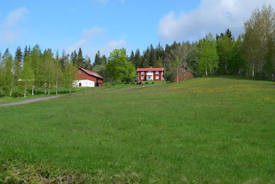
Several kilometers south of Stjärnfors, the trail goes through the fields of the Stuttjärn, which lies high upon a moraine slope. Some of the buildings here are very old and are of cultural significance.
The estate is typical of the kind of Finnish colonization that occurred in these desolate areas of Bergslagen during the 1600s and gives clues to the farming practices of the time. The higher agricultural grounds helped to reduce the risk of frost to the crops.
3. Vintermossen
The village Vintermossen is of the same terrain as Stuttjärn, and its roots also go back to Finnish colonization in the 1600s.
Expansion here has created a relatively large village and several of the estates are still in operation.
Before the village the trail crosses one of the village’s farmed marshlands, now
abandoned and overgrown. As the population grew and slash and burn agriculture became limited by the mining industry’s need for forest, the problem of new farmland became an issue. A common solution to this
problem was to dig up and farm the nearby marshlands.
The problems with marshland farming were many, foremost being that
frost was troublesome due to the low terrain. Marsh farming practices in general were abandoned long before farming on higher grounds was.
From
Mount Rifallshöjden then go down the trail towards former farmland
around mosquito Sjötorpsvägen.
4. Mackarsberg
Mackarsberg gives one of the best views in Ljusnarsberg. The mountain is not one of the highest in the district (about 375 m above sea level), but it is bare and therefore makes for a great view from the tower here, although dependent on how the nearby forest is taken care of.
Of
Mosquito Sjötorpsvägen can today to see traces of foundations and
basement, and the well-preserved stone ruins of the barn.
5. Kvarnruinen
Just before the rest area by Rasbackstjärn, there is a short looping trail that leads to the ruins of a small grain mill. This type of mill was referred to as a “streaming mill”, which means that no dams were built, but instead stones were used to focus the rapids into a water wheel. Most villages and even some estates had these mills in order to avoid having to transport grain in order to have it milled.
After 8 kilometer hike you will arrive at a peculiar boulders, called "stone on Stone".
The whole environment is characterized by large boulders and ice depredations. Around the block grows enchanted forest.
6. Kindlahöjden
Kindlahöjden, 425 meters above sea level, is one of the county’s highest points. Higher points can only be found northwest, near the Värmland border. With Röberget and Kalklinten, Kindlahöjden forms one of the county’s most inaccessible and heavy wilderness areas, which is also a nature reserve.
The reserve’s trails are connected to the Bergslag Trail.
At Kindla’s summit, there is an 11-meter viewing tower, which allows one to rise over the treetops to get a fantastic view over the forests of Bergslagen.
After rouning Winter bog Bergslagleden on Mackar Berg, one Ljusnarsberg most classic view points.
7. Nyberget
Nyberget has been a mountain village since 1539, when the smelting house was the center for four state-owned mining facilities. Early on, the smelting house was built on the brook between Dammsjön and Gränsjön.Production ended in 1809, after which the village has survived on forestry, as well as on iron refining and sawmill work, based in the nearby Hammarbacken.
Stations Mountains located at 375 meters altitude and has lookout tower offering spectacular views in all directions.
Four
kilometers north visible Salbosjön, and beyond the lake Ljusnaren.
The village Winter moss is an old finnby with roots from the 1600s.
After the rest area will Bergslagsleden until Kindla nature reserve, Which is Unmatched contiguous wilderness ans roadless area in the Örebro region.
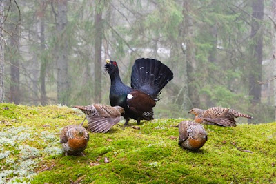
In Kindla have all four large predators observed, both bears and wolves as lynx and wolverine. Thrive here three-toed woodpeckers in old-growth forest, as well as forest birds such as the capercaillie, black grouse and hazel grouse.
Skvattram is a characteristic plant of the bogs in Bergslagen.
Overview map:
Important to know
● Make fires only where designated fire rings/circles are present.
● Make sure that your fire is completely out before you continue hiking.
● Refrain from starting fires during the dry periods of summer when risk of forest fire is high.
● Do not break off limbs or branches from living trees.
● You may pitch tents along the trail, but preferably near the rest areas and
not more that one night in the same place.
● Do not stray from the trail when near built-up areas, cultivated fields or planted forests.
● Do not litter.
● If hiking with a dog, be aware that you must always have the dog on a lead/leash in the forests/fields during the period from March 1 - August 20.
● So as to avoid conflicting with moose hunting season, you shouldn’t use the trail during the most intensive hunting period - the second week in October and several weeks forward.
Facts about the Bergslag Trail
(Bergslagsleden)
The Bergslag Trail is a 280 km hiking trail
passing through the entire county of Örebro. It is divided into 17 stages. The agency responsible for the trail is Regionförbundet Örebro. The Bergslag Trail is identified by orange markings on trees or on posts. At
road crossings or when the trail branches, directional arrows with the Bergslag Trail symbol appear. The Bergslag Trail forms part of European walking route E1, which extends from southern Italy to the Swedish
mountains. www.stfturist.se
Bus Connections
There is no regular bus traffic to Kloten.
Information on bus schedules: +46 771-22 40 00 Suggested reading (Swedish)
Esbjörnsson, Estrid, Värt att se i Örebro Län; Lindstén Carl Anders, Sevärt i Södra Kilsbergen; Hellström, Lena, Utsikt från Bergslagsleden.
For further information
Kopparberg Tourist Office: +46 580-805 55,
http://www.ljusnarsberg.se; Örebro County Regional
Development Council, +46 (0)19-602 63 00,
Home page for outdoor life
At http://www.regionorebro.se you can find a collection of information on nature and outdoor life in the Örebro region. It contains
current information on places to stay along
the Bergslag Trail. You can download pages
on trail stages and get suggestions for other
activities. The home page also has information on fishing opportunities, canoe rentals
and links to activity organisers.
HIKINGTIPS: KONTAKT
For more detailed information see contact below.
HIKINGTIPS: KONTAKT
For more detailed information see contact below.

BERGSLAGEN ETAPP 1-7
Kopparbergs turistbyrå - 0580-805 55,turism@ljusnarsberg.se
Nora turistbyrå — 0587-811 20, info@nora.se
Lindesbergs turistbyrå — 0581-811 70,turistinfo@lindesberg.se
KILSBERGEN ETAPP 8-13
Örebrokompaniet — 019-21 21 21, info@orebrokompaniet.se
Kilsbergen konferens & lodge — 019-29 55 00, info@kilsbergen.se
TIVEDEN ETAPP 14-17
Laxå turistbyrå - 0584-109 20, turistbyra@laxa.se
Askersunds turistbyrå - 0583-810 88, turistbyran@askersund.se
Tivedstorp - 0584-47 20 90, info@tivedstorp.se
ANSVARIG PÅ REGIONFÖRBUNDET
Kjell-Ove Nordström, 019-602 63 41


