SWEDEN: Bergslagsleden Stage 2
Gillersklack – Stjärnfors 17 km
Gillersklack
Gillersklack is about 6 km north of Kopparberg. Follow signs from highway 50. Camping available. Other Gillersklack accommodations include cabins, a hostel, food, coffee and swimming. Information:
tel. +46 580-125 00 or the tourist offi ce in Kopparberg, tel. +46 580-805 55,
Stjärnfors
The café near highway 63 is open during the summer season. Near this checkpoint on the trail is Stjärnfors Manor and homestead museum. Parking is located between the highway and the lake. Swimming area with shelter. Lodging available during the summer in the cabins next to the café or in self-catered apartments.
Information and booking via telephone: +46 580-410 20, -410 46.

In
Stjärnsfors available in the summertime cafe by the main road and
food service at the golf restaurant.
Rest Area Olovsjön
Rest area with shelter, fire ring, garbage containers and toilet is found
west of the railroad tracks where the lake, Olovssjön, lets out into the stream Garhytteån. No drinking water. Nice beach. Take your garbage when leaving.
What to See Along the Way
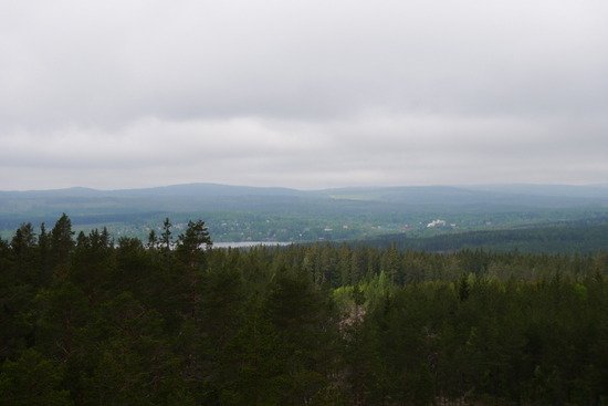
1. Gillersklack’s Great Outdoors
North of Kopparberg and east of highway
50, Gillersklack sits on a plateau, its highest point at 407 meters above sea level. The trail’s Gillersklack checkpoint is found high on the western slope. From the top, one enjoys a wide view over the Ljusnarsberg area. The conditions provide for good slalom and cross-country skiing.

Phase
two is the winding paths in the forests of Bergslagen.
2. Finngruvan
A kilometer west of the highway, the trail passes through the copper mining region of Finngruvan. In the area, there are 12 large and small mining holes and a number of mining mounds.
Ore deposits were discovered in the late 1600s and were extracted in large scale during the 1700s, after which the ore began to run out. The mining ended in the mid-1800s.
In several of the mines, the smooth sides of the walls show that the mining occurred without the use of gunpowder, but with a process that used burning wood and water casting.
Mining in Finngruvan led to the building of copper smelting houses at Högfors and Born. For a while, a 1700-meter long system of horizontal shafts ran from Högforsälven to Born and drove the pumps in the mine. The mining district gives wide views over the area. The mining mounds that can be seen have been responsible for the drainage of poisons that still exist in the mounds. The
poisons follow the surface and ground waters down the slopes and then damage or destroy vegetation.
Just west of the mining area, the trail passes a nearly vegetation free environment, caused by the poisoned water.
View
of Bergslagen
3. Björkberg
East of Olovssjön the trail passes over majestic heights and then down the slope, giving limited views of the region around Ljusnaren. The fact that both the valleys and the higher areas have been used for agriculture is
possible due to the impressive walls of stone in the forest along the path at Björkberget.
On the ground that slopes down to Olovssjön, the trail passes several small mining holes. While these holes are said to have been test holes, they show the amount of work that was done to find ore deposits in this copper mountain district.

A
one-mile west of the highway, the trail passes right through Finn
mine's copper mining area.
4. Finnshyttehedarna
After passing Garhytteån, a source of Arbogaån, the trail emerges into a heath
of pine. Ridges dominate the area north of the highway towards Skäret, while the area to the south is dominated by shifting sand dunes. Ice rivers and the melting of inland ice created the streams and the ”dead ice” craters. The sand dunes were created later, but before vegetation could grow in the cold, windy tundra climate.

In
the woods on top of Birch Hill, the trail follows a mighty stone
wall.
5. Djäkens bygge
The trail makes its way down to the lake Ljusnarn to the community swimming area, Djäkens bygge. There is a parking area and, during the summer, access to toilets.

Rest
area at Olovsjön.
6. Ljusnarsbergen
South of Djäkens bygge, the trail follows Ljusnarn to the stage’s finish at Stjärnfors. Of the many fine lake views, the best is experienced from Ljusnarsbergen, 2 km south of Djäkens bygge. On the other side of the
lake, Nittälven flows, known for its backwoods character and for being one of the county’s most exciting canoe routes.

The
trail reaches the lake Ljusnarn at the municipal swimming Djäkens
construction.
7. Stjärnfors
As the Rällsälven flows out of the Ljusnarn, the presence of ore and the possibility of hydropower created a natural center for regional industry.
Unlike the other industrial communities in Kopparberg’s mountain district, the focus here was not on copper, but on the rich occurrences of iron ore.
The privilege of starting an iron forge was given to Stjärnfors in 1676. Stjärnfors later grew to be a center for the refinement of iron from the smelt houses of the area, even using Bessemer converters.
Production was ended in 1905, but the flowing water is still used by a power station, which means that the dams and canals have been preserved. The Stjärnfors Manor has also been kept, whereas the surrounding fields are primarily used as a golf course.

The
trail then alternately up and down, sometimes in spruce and
occasionally in the pine forest.

View
of Ljusnarn.
Overview map:

Accommodation and service phase 2
transport
From Örebro takes you by bus or train to Kopparberg. From here you can take taxi to Gillersklack or go on trail 2 km from the Kopparberg station.
http://www.tagkompaniet.se
http://www.bangbro.se/se
Windbreaks
There are two shelters along the trail, at Olovsjön and Stjärnsfors. There is also a toilet and fireplace.
water
At Gillersklack or Kopparberg.
Food
In Kopparberg center you will find both supermarkets and restaurants.
HIKINGTIPS: KONTAKT
For more detailed information see contact below.

BERGSLAGEN ETAPP 1-7
Kopparbergs turistbyrå - 0580-805 55,turism@ljusnarsberg.se
Nora turistbyrå — 0587-811 20, info@nora.se
Lindesbergs turistbyrå — 0581-811 70,turistinfo@lindesberg.se
KILSBERGEN ETAPP 8-13
Örebrokompaniet — 019-21 21 21, info@orebrokompaniet.se
Kilsbergen konferens & lodge — 019-29 55 00, info@kilsbergen.se
TIVEDEN ETAPP 14-17
Laxå turistbyrå - 0584-109 20, turistbyra@laxa.se
Askersunds turistbyrå - 0583-810 88, turistbyran@askersund.se
Tivedstorp - 0584-47 20 90, info@tivedstorp.se
ANSVARIG PÅ REGIONFÖRBUNDET
Kjell-Ove Nordström, 019-602 63 41
Du kan även mejla oss på:
naturochfriluftsliv@regionorebro.se
naturochfriluftsliv@regionorebro.se