Digerberget – Mogetorp 16 km

SWEDEN: Bergslagsleden Stage 7
Digerberget – Mogetorp 16 km

Pershyttan
Pershyttan
The cafe in Pershyttan is housed 
in the old railway carriages.


Difficulty:

 3 


Height: 

16 km


Estimated time:

 4 hr


Surface:

 Level changes - mostly redwoods, but also forest.
The walk starts at Digerberget, as winter is a skier's paradise for nora residents. The first route is on the ski tracks, and then fold up in the woods. The trail here near the nature reserve Myllypuro-Lerkesån.
In the river, there are plenty of freshwater pearl mussels of different ages, indicating that the new clams produced. This suggests in turn that the living environment is also good for trout, since the freshwater pearl mussel larvae in about nine months, live as parasites on trout gills. 
After a short climb up a pine-covered height, tassel Titmouse is a common bird, the trail was to bergmansbyn Pershyttan. 

The water source in Pershyttan


Pershyttan is a mining village where miners mining iron ore and iron produced since the 1300s. The scenery around the village are many traces and remains that tell of mining 700-year history. There's everything from charcoal pits and slag heaps, the croft ruins and overgrown fields.

Visit Mine


In Pershyttan's summertime visit mine caps mine, where the guided tour can go down in the mine. There are also guided tours that go to Pershyttans Foundry.Operations at the foundry ceased as late as in 1953 and the mine closed in 1967.
In Pershyttan's summer a restaurant and a coffee shop in a couple of vintage coaches. From Pershyttan you can take a detour with the railcar into the attractive wooden town of Nora. During the holidays we also run steam locomotives. In Pershyttan crosses Bergslagsleden in several places a colored yellow trail, which is about 6 km long and leads you past Pershyttans many cultural monuments.

Pole Walking


From Pershyttan the trail next to the country's only waterwheel with rod again in working order. The restored rail time is 200 meters long and begins at the restored water wheel. Rod Aisle transferred power from the water wheel to pump the mines.
The trail passes some typical estates, with its long, narrow houses and typical cast iron chimneys, before re-entering the forest.
Pole Walking
Pole Walking

Bath and channel


After 3.5 km you will pass Bergslagsleden Dammsjön, where there is a nice little beach, located a few hundred yards west of the trail. Dammsjön has for centuries played an important role as the reservoir in order to conserve water for the many water wheels needed cab and mining in Pershyttan.
South of Dammsjön trail follows a hand-dug canal, which is more than a kilometer long. It was excavated in the 1800s to bring over from the stream Lerkesån water Dammsjön. In that way the water flow is increased in the stream that ran water wheels in Pershyttan. There is also a picnic table at a small quiet water lagoon in the channel.

Along the old road


After 5.6 km the trail to a trail junction. Bergslagsleden continue south over a bridge, while the blue-marked circular trail takes you back to Digerberget.
Loop trail Digerberget is 9 km long and starts appropriate from Digerberget.From there, the trail goes up a hill and follow in a while a very old riding and wagon trail. On the road by horse ore from Pershyttan and other mines in the region to Nora Ramshyttan and other foundries further south in Kilsbergen. The path is very deep in the ground, a so called covert.

Nice view


Up on the hill is a large clear-cut area, which offers great views to the north and northwest. The felling sway a grass called wavy hair-grass. From here the trail a bit on the verge of Bofors artillery range, which is one of Kilsbergen firing range where test launches will take place at certain times of the year.
After crossing the road between Wedge and Nora trail crosses another couple of large clearings. A well-known landmark for all närkingar is the large telecommunications mast in Lockhyttan that supplies the entire county with radio and television broadcasts.

Much needed break


After 8.7 km you will reach Kvarndammen, which is stage's rest. It offers shelter, fire, and dry toilet.
After rest and food, continue south. The trail passes a large deer fence before entering the pretty little village Ramshyttan.
Even in Ramshyttan have iron industry was conducted in substantial quantities.The trail passes the stream through the village at the place where the foundry legacy. Ramshyttan, after smelting closure, for a long time been the center of administration of Örebro paper large forest holdings in Kilsbergen. Forest office was housed in a distinctive red building that trail passes just after the creek.
Approximately 600 meters west of Ramshyttan are Ramsjön having bathing.Where will you follow the road that the trail comes out at just after resting Kvarndammen.
Ramshyttan
Ramshyttan


From Ramshyttan


Bergslagsleden leaves Ramshyttan at 192 meters above sea level and goes down through the overgrown pastures. After 800 meters follow the trail for a while an old drive and after another 2.2 km trail passes some clear shingle banks. The area is called Sågställningsbottnarna, which is just below the highest coastline. They have been formed by wave action, then the land surface after deglaciation for some 10 000 years ago emerged from the preliminary stage of the Baltic Sea called Yoldia.
3km from Ramshyttan you come to a trail crosses, which you can see to the south the mighty Amboberget. It is possible to by a marked blue connecting link to take a shortcut directly down to the stage. The trail is also part of the 11 km long circular trail that starts in Mogetorp and goes over Amboberget. From Amboberget you have a fantastic view to the east. The landscape is varied with a mixture of large forests, swamps and gullies.


'Cabin in Rökärr


Bergslagsleden then goes through a fancy party with old spruce, before it arrives at the small rest house in Rökärr. The cottage is always open for a visit and located by an old Kilsbergstorp. The remains of the crofter toil is still visible and the housing northwestern end grows an old spirea. There is also maple and crab apple.
South lie the blue marked point, which is part of the 8 km round loop Rökärr starting in Mogetorp. Bergslagsleden continues eastward and goes under the big power line from northern and up on a clearing. Felling area offers nice views of both Amboberget and mast Lockhyttan. Furthermore, the trail crosses a small bog, where cloudberries and Labrador tea grows among the tussocks.


Skärmarbodabergen


After the bog, you can imagine the excitement cave area Skärmarbodabergen.In Skärmarbodabergen is an accumulation of great ice age memories, you can not directly find anywhere else in Sweden. There are steep cliffs isslipade, individual dramatically placed boulders, ice and water blasted rock parties, sprickbranter and rock accumulations and caves.
The area has several trails, which offers fun for the whole family and the 400 year-old pine forest are among the most protected in the county. The starting point for an excursion in Skärmarbodabergen located just west of highway 50, after Nora exit. More information is available at the rest area Bergslagsresan sport, which is north of Mogetorp.
A small detour from the trail takes you among other things to what is called Blockbergsramlet, with several large blocks caves, and, if you like, out into Skärmarbodabergen stignät.
During the last stretch towards Mogetorp trail through mixed forest and up over a couple of pine slabs. Civilization makes itself felt through the traffic noise from Highway 50 and just däreftter is Bergslagsleden arrived at Mogetorp.
At Mogetorp Coffee and food service, as well as overnight accommodation and shower. From here frequent buses to Örebro. Mogetorp, located at 63 meters above sea level, is also one of the starting points for a tour of the block cave area. At most, the leg had been up more than 200 meters. 
Overview map:
What to See Along the Way:

1. Digerberget
Digerberget is the northernmost part of Kilsbergen. There is a great view of Nora from the mountaintop, which is more than 100 m above the surrounding areas. 
In the winter, several of the trails are lighted. The ski track Kilsbergspåret starts at Digerberget and goes south 27 km to Ånnaboda.
The walk starts at Digerberget, as winter is a skier's paradise for nora resident.
The first route is on the ski tracks, and then fold up in the woods.The trail here near the nature reserve Myllypuro-Lerkesån.
2. Pershyttan
Pershyttan is one of the county’s best-kept mining villages, and one of the oldest, dating from the 1300s. 
Smelting production ceased in 1953 and the mine closed in 1967.
Along the trail is Sweden’s only waterwheel with functioning wooden shaft pumping system. 
The system of wooden poles is 200 m long and starts at the restored waterwheel. 
This system utilized the power from the waterwheel to pump out water from 
the mines. 
Displays are available during the summer.
The path swings by a well-preserved smelt house as well as a miner’s estate from the 17- and 1800s with working quarters, a forge and a coalhouse.
The Nora Bergslag Veteran Railway owns Pershyttan. 
Tracks now go to the smelting house, meaning it is possible to take the train 
from Nora to Pershyttan. 
In Pershyttan, the Bergslag Trail crosses a yellow-marked path of 6 km that takes visitors by many of the town’s historical monuments.
Pershyttan is a mining village where miners mining iron produced since the 1300s.

3. Dammsjön
Dammsjön Lake has for many years served an important role as the reservoir for the water that powered the waterwheels that drove the mining work in Pershyttan. 
By the northern part of the lake is a small swimming area just 200 m west of the trail.
There is a summer restaurant and a coffee shop in a couple of vintage coaches.
4. The canal
South of Dammsjön, the trail follows a hand-dug canal. 
The canal, which is over a kilometer long, was created in the 1800s to bring over water from the stream Lerkesån to Dammsjön. 
In that way, the pressure in the stream that drove the waterwheel in Pershyttan increased. 
This was yet another example of the importance of water power during the 
iron days of Bergslagen.
In Pershyttan's summertime visit mine caps mine, where the guided tour can go down in the mine.
5. Wagon trail
South of the canal, the path travels along the old riding and wagon trail on which ore from Pershyttan and other mines were transported by horse and cart to Ramshyttan and other smelting houses to the south. 
The fact that the road was well traveled is evidenced by the fact that the current path runs in a very deep depression in the earth.
After 8.7 km you will reach Kvarndammen, which is stage's rest. It offers shelter, fire, and dry toilet.
6. Ramshyttan
Iron working has also played a big role in Ramshyttan. 
The trail goes by the stream and village to where the smelt house stood. 
After the smelt house closed, Ramshyttan was the administrative center of the large forests in Kilsbergen, owned by the Örebro paper industry.
Kvarndammen.
7. Sågställningsbottnarna
Just after the trail leaves the forest road north of Amboberget, it passes some very noteworthy shingle banks. 
This area is called Sågställningsbottnarna. 
These were created about 10,000 years ago by the splashing of waves in the early stages of the Baltic Sea (then called Yoldiahavet) when the land was 
still depressed from melted inland ice.
Rökärrsstugan is always open for a visit and located by an old Kilsbergstorp.

8. Amboberget viewpoint
A marked trail goes from stage 7 of the Bergslag Trail to the mountain Amboberget. It is possible to continue south and connect to stage number 8.
In rocky pine forest around Skärmarbodabergen are plenty of cranberries.

9. Skärmarbodabergen
In Skärmarbodabergen there is a wondrous assortment of Ice Age remnants that are not found anywhere else in Örebro County. 
There are steep, ice-sharpened mountain ledges, random dramatically placed boulders and blocks, ice- and water-cracked stones, sharp drop-offs and rock accumulations and caves. 
The 400-year-old pine forest is one of the most protected in the county. 
There are many hiking trails in the area, offering fun for the whole family. 
The starting point for an outing to Skärmarbodabergen is just to the west of highway 50, after the Nora exit. 
More information on the area can be found at the Bergslagsporten rest area, north of Mogetorp.
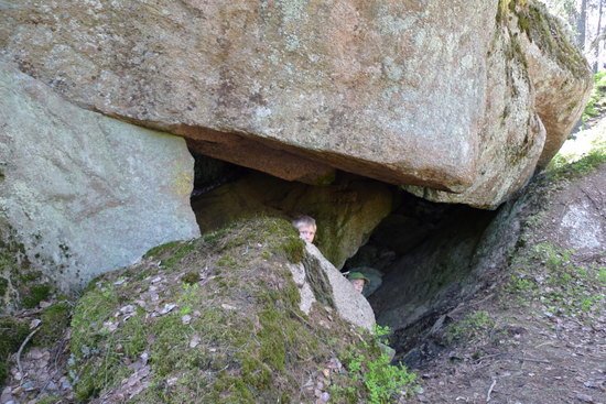
In Skärmarbodabergen is an accumulation of great ice-age memories, you can not Directly find anywhere else in Sweden. There are steep cliffs isslipade, individualists Dramatically placed boulders, ice and water blasted rock parties, sprickbranter and rock accumulations and caves.

At Mogetorp Coffee and food service, as well as overnight accommodations and shower. From here frequent buses to Örebro.

Accommodation and service stage 7

Transport 
At the bus stop Cellar neck, heading 244 towards Nora, you can get off and walk on the trail that crosses the road. Mogetorp on Highway 50, served several times daily (Orebro - Nora).


Accommodation
Pershyttan is a heritage that should not be missed along the trail. Here we eat good homemade food at a party express next hut, take the steam train to the wooden town of Nora and lives in a small red house on a Bergsmansgård in Pershyttan. Your experience of the old Sweden's total.
For accommodation call the Gallery Victoria - 0707-814 46 0587-121 07

In Ramshyttan do you live nicely in a converted mews. The proprietress is rounder, making speech barracks into accommodation you will remember and return to. The surroundings are breathtaking and the village offers a wide summer program. Therefore, there is a risk that you stay longer than you intended.
For reservations: info@lenahellstrom.se, 0705-28 40 63
  
At Ramsjöns beach you will find an old village school, which today has become a home for the soul. Here you can enjoy nature and tranquility. It is Ragnar and Lena who will welcome you.
   
At Mogetorp, located adjacent to Highway 50, you will find an inn that has both good food and accommodation.
For reservations, call 019-28 20 71
  

Windbreaks
There are two shelters along the trail. At the stage start and at the mill pond adjacent Ramsjön. At these locations are both toilet and barbecue.


Water
At the stage start and milestones. You are also water in Pershyttan and Ramshyttan.


Food
To sit in Pershyttan on Kalas Expressen is a very pleasant dining experience. Both the food is homemade apple pie.

Mogetorp serves good food and has a nice accommodation. Contact, see above.

Other activities
Guided tours of Pershyttans cultural environment. see http://www.visitnora.se
Skärmarbodabergen caves at Mogetorp are well worth a visit. Rocks formations (about 120 pcs.) Are clear signs of nature from the last glacial melting. Information about guided tours can be found at: www.hopajola.se
Ramshyttan has several byaktiviteter in summer. Contact any of Lodging in Ramshyttan.


Hammarby – Digerberget 14 km

SWEDEN: Bergslagsleden Stage 6
Hammarby – Digerberget 14 km

Difficulty:

 3
Height: 14 km

Estimated time:

 3.5 hrs 

Surface:

 Elevation - redwoods and forest road.
The trail starts at the blast ruin of Gisle foundry, which was in operation from the year 1602 to 1698. The place is called Hyttfallet and is the top case in Järleån downstream Norasjön. Already in 1544 there were a miner's hut and the same year began the so-called King Hammer will be constructed on the orders of King Gustav Vasa.

Hammarby use


The development of the iron industry has for centuries meant the expansion and renovation of facilities at what came to be called Hammarby Mill. The business was only completed in 1923 when the recently restored iron works closed down for good.
The trail then crosses Järleån. Here you can take a detour into Järleåns nature reserve, which runs downstream river.Järleåns Nature Reserve includes land on both sides of the river and extends from Hyttfallet and about 4 km downstream to Järle mill.
The reserve has been partly to protect the river and valley with its rapids, canyon formations and lush vegetation. To protect the cultural landscape and cultural history from the iron industry's heyday.
Most notable is perhaps the completely unaffected Långforsen, which has a vertical drop of more than 20 meters below its 1,200-meter races. In Hammarby community center, which is 500 meters away, there are accommodation facilities.
Foundry by Hammarby
Foundry by Hammarby

Cold Source


After 1km, the trail passes a spring, whose clear water constantly seeps out of the rock. The water tastes great, but drinking at your own risk. The stage then go out on a clearcut and then out through a sandy pine forest. The path leads up to 185 meters above sea level. Up on the mountain Röbraket are treated to a nice view of the church and Nora Nora Lake. Up here on the skinny pine heath is crested tit and gray flycatcher common birds. Capercaillie also thrive in height.
Then the trail goes down, crossed over a small stream and goes into an old-growth forest area. There are over a century of spruce and occasional pines that are over 200 years old. East of the trail is an exciting block cave area with large boulders, which is overgrown with damp moss.
3,7 km from Hammarby's an old conifer that has been long and decayed.Today, the tree shelter for beetles and other insects that feed on old dead tree.Also close by are the remains of a hut.

Nice view


After 4.5 km, a marked looping up to view punk at Big Mountain. Dead-end trail is 200 meters and leads up to a mountain plateau with distinctive pine forest with many old pines. From Big Mountain, you have a wide view to the west and south, with Nora area in the north and Kilsbergen northernmost foothills to the south.
POTHOLE
POTHOLE
About 1.5 km after the Big Mountain is a marked looping of approximately 300 meters walking by two huge potholes.Potholes are circular hollows in rocks, probably formed by a so-called löparsten started to rotate in an unevenness of the rock surface, as a result of water that flowed down like a waterfall in a vertical shaft in the ice sheet. The round stone found in one of the potholes is the last, and not yet worn out, of the stones with water through eroded rock.
5,7 km from the start of Hammarby is Uvberget, which has a picnic area with shelter, fire and dry toilet, which is located near a small stream.

Sweden's oldest railway


After the rest area, the trail, through among forest vegetation, to the little village Basement neck. Here the trail passes the railroad Ervalla-Nora, who until the end of the 1970s were included in AB Nora Bergslagen Railways individual networks. It was opened in 1856 and is the oldest standard gauge railway. The railway is now maintained as a museum railway traffic during the summer. It is possible to go including from Pershyttan, which you pass on Stage 7.
Just south of the railway, at County Road 244, has frequent bus connections to Örebro and Nora.

Mosse


After passing civilization, the trail over a relatively large bog. This has long and widely been used for peat extraction. Sprinkle Peat, including use of urban dry toilets and avfallshanteringhar, during the first half of the 1900s, an important commodity. At the trail grows cloudberry, bilberry and crowberry.
Kilsbergen northernmost utlöpar is Digerberget, from whose top you have a broad view of Nora district. Today Digerberget Nora Municipality's sports and recreation center. Here's the summertime several hiking options, and during the winter ski trails. Skidspåret Kilsbergspåret, leading to Ånnaboda, starts in Digerberget.
At Digerberget are shelters with campfire and outside the ski resort has a water faucet.

What to See Along the Way:

1. Hyttfallet
Stage 6 starts at Hyttfallet, which are the topmost falls of Järleån downstream of Norasjön. 
Hyttfallet, and the buildings that have been built here, played a huge role in 
the development of iron refinement in the area and in all of Nora. 
A smelt house existed here as early as 1544. 
During that year, the so-called Kungshammaren (King’s Hammer) was established by the order of Gustav Vasa. 
The development of iron production has for centuries been cause for constant renovation to the buildings that came to be known as Hammarby. Production ended in 1923 when the then newly restored ironworks was closed.
The trail starts at the blast ruin of Gisle foundry, wich was operation from the year 1602 to 1698.
The place is called Hyttfallet and is the top case in Järleån downstream Norasjön.

2. Järleåns nature reserve
The reserve is on both sides of the stream and stretches downstream 4 km from Hyttfallet to Järle kvarn. 
The reserve was created to protect the stream and valley, along with the rapids, ravine formations and luxurious vegetation, while preserving the cultural 
significance of the glory days of iron production.
Perhaps most noteworthy is the untouched Långforsen rapids which have a descent of more than 20 m during its 1 200 m stretch. 
There is a 6 km long rambling path through the entire reserve, from Hyttfallet to Järle kvarn. 
Along the path there are several rest areas and information boards.
Visitors can stay overnight in Hammarby community center.

3. Mountain viewpoint: Röbraket 
2 km after Hyttfallet, the trail goes over one of the area’s highest mountains, 185 meters above sea level and about 100 m above the surface of Norasjön. From the trail, one has a wide view west over Nora. 
The lake in the foreground is Norasjön, behind which is the town of Nora and its prominent church.
Bergslagsleden passes the edge of Järlåns reserve.

4. Stora Berget (Big Mountain)
After an additional 2 km are signs that lead to another mountain viewpoint: Stora Berget. 
The looping trail that leads there is 200 m long, ending on a mountain plateau with a distinct mountain pine tree forest. 
From Stora Berget one has a wide view toward the west and south with Nora in the north and the northernmost part of Kilsbergen in the south.
After 1 km, the trail passes a spring, whose clear water constantly seeps out os the rock.

5. Giant burrows
15 km after Stora Berget is a marked 300 m looping path that goes by two very large burrows. 
Giant burrows are comprised of hollowed-out spots in the mountain that were created when a large stone fastened at an uneven place on the mountain, and then rotated under the flow of running water.
The giant burrows were created by water that flowed like a waterfall through a vertical shaft in the inland ice. 
The round stone, seen in one of the giant burrows, is the last, but still not worn down, stone that hollowed out the mountain with the water’s help.
After 4.5 km, a marked looping up to view punk at Big Mountain. Dead-end trail is 200 meters and leads up to a mountain plateau with distinctive pine forest with many old pines. From Big Mountain, you have a wide view to the west and south, with Nora area in the north and Kilsbergen northernmost foothills to the south.
6. Järnvägen
Near the village Källarhalsen, the trail passes the Ervalla-Nora railway. 
This railroad, which up until the end of the 1970s was part of AB Nora Bergslags Järnägar’s railway network, is Sweden’s oldest regular track railroad, started in 1856. 
The railroad is now a museum, operating during summer.
5,7 km from the start of Hammarby is Uvberget, wich has a picnic area with shelter, fire place and dry toilet, which is located near a small stream.

7. Torvmossen
After the trail passes the railroad and county road Örebro-Nora, it goes out over a relatively large peat bog. 
This bog has for many years and to a large extent been used for peat coverings.
Peat moss was an extremely important product during the first half of the 1900s, used both for dry toilets and for waste handling.
Crowberry is a common plant on the marshes along the trail.

8. Digerberget
Digerberget is the northernmost part of Kilsberget. 
There is a great view of Nora from the mountaintop. 
Digerberget is Nora’s outdoor activity center. 
The summer has many hiking choices while the winter provides cross-country ski tracks. 
The ski track Kilsbergspåret starts at Digerberget.
South of Digerberget is the Pershyttan hiking area, with many hiking alternatives. 
In the summer there is a train restaurant and café in Pershyttan.
After the rest area, the trail through among forest vegetation, to the little village Basement neck.
Here the trail passes the railroad Ervalla-Nora, who until the end of the 1970s were included in AB Nora Bergslagen Railways individual networks. It was opened in 1856 and is the oldest standard gauge railway. The railway is now maintained as a museum railway traffic during the summer.

Today Digerberget Nora Municpality's sports and recreation center. Here's the summertime several hiking options, and during the winter ski trails. Skidspåret Kilsbergspåret, leading to Ånnaboda, starts in Digerberget. At Digerberget are shelters with campfire and outside the resort has a water faucet.

Overview map:

Important to know
● Make fires only where designated fire rings/circles are present.

● Make sure that your fire is completely out before you continue hiking.

● Refrain from starting fires during the dry periods of summer when risk of forest fire is high.

● Do not break off limbs or branches from living trees.

● You may pitch tents along the trail, but preferably near the rest areas and 
not more that one night in the same place.

● Do not stray from the trail when near built-up areas, cultivated fields or planted forests.

● Do not litter.

● If hiking with a dog, be aware that you must always have the dog on a lead/leash in the forests/fields during the period from March 1 - August 20.

● So as to avoid conflicting with moose hunting season, you shouldn’t use the    trail during the most intensive hunting period - the second week in October and several weeks forward.


Facts about the Bergslag Trail 
(Bergslagsleden)
The Bergslag Trail is a 280 km hiking trail 

passing through the entire county of Örebro. It is divided into 17 stages. The agency responsible for the trail is Regionförbundet Örebro. The Bergslag Trail is identified by orange markings on trees or on posts. At 
road crossings or when the trail branches, directional arrows with the Bergslag Trail symbol appear. The Bergslag Trail forms part of European walking route E1, which extends from southern Italy to the Swedish 
mountains. www.stfturist.se
Club, which means you have a nice restaurant to look forward to. 
The cottages are brightly decorated and contains separate rooms, kitchen and toilet. 
Down by the lake there bath, sauna and barbecue area. 
www.sundbystugby.com 0587-311 662
 

Windbreaks


There is a shelter at Uvberget. There is also a fireplace and toilet.
 

Water


Water is at the stage start and milestones. There is also a spring 1 km south of Hammarby.
 

Food


In Hammarby, you can get yourself a packed lunch and at Nora Golf Club you can both coffee or lunch. If you have the energy, you can walk past the milestone Digerberget and continues to Pershyttan. Here you will find both food and accommodation.


Bus Connections

Transport


There are frequent buses on Highway 50. Get off at Järleån and wander through Järleåns Reserve. You can also choose to go toward Nora and get off at Basement neck. Where the trail crosses Highway 244. 
http://www.lanstrafiken.se

Accommodation


Jerla Farm


Jerle Farm can be found at Järleåns Reserve. It offers a relaxed rural idyll next Järleån. The farm is a Bergsmansgård from the 1700s, where the family made ​​on one wing of a B & B. Here you can enjoy the surroundings with Järle on and pastures as backdrop. The farm's pool is likely to attract a dip. 
For reservations call Monika Aune - 0587 920 88 070-823 96 16 
www.jerlegard.se
 

Hammarby community center


Hammarby community center is located at the outskirts of Järleåns Nature Reserve and is open to hikers during the summer season. In the old building, there are a number of simple rooms upstairs. There is a kitchen, shower and toilet. 
For reservations, call Christina Haglund 070-379 20 82 
www.hammarbybygdegard.se
  
Old Works office at the mill in Hammarby has been converted to a very nice private accommodation. Here are 3 rooms with 2 beds in each room. Kitchen and toilet facilities are shared. Bicycles are available for rent if you want to stop and enjoy the beautiful surroundings, and Järleåns Reserve is around the corner. 
turisten@hammarby-nora.se , 070 510 96 58, 070 543 27 25
 

Sundby Cabins


Sundby Cabins can be found at Nora Lake and the route is marked from the trail. The holiday village is located next to Nora Golf 

Other activities

  • If you stop at Sundby Cabins can play golf in the beautiful Bergslagen environment or embark on a canoe.
  • Down by Norajön sauna.


For further information
Kopparberg Tourist Office: +46 580-805 55, 
http://www.ljusnarsberg.se; Örebro County Regional 

Development Council, +46 (0)19-602 63 00, 

Home page for outdoor life
At http://www.regionorebro.se you can find a collection of information on nature and outdoor life in the Örebro region. It contains 
current information on places to stay along 
the Bergslag Trail. You can download pages 
on trail stages and get suggestions for other 
activities. The home page also has information on fishing opportunities, canoe rentals 
and links to activity organisers.


HIKINGTIPS: KONTAKT

For more detailed information see contact below.


HIKINGTIPS: KONTAKT

For more detailed information see contact below.


BERGSLAGEN ETAPP 1-7

     
Kopparbergs turistbyrå - 0580-805 55,turism@ljusnarsberg.se

Nora turistbyrå — 0587-811 20, info@nora.se

Lindesbergs turistbyrå — 0581-811 70,turistinfo@lindesberg.se


KILSBERGEN ETAPP 8-13

       
Örebrokompaniet — 019-21 21 21, info@orebrokompaniet.se
Kilsbergen konferens & lodge — 019-29 55 00, info@kilsbergen.se


TIVEDEN ETAPP 14-17

      
Laxå turistbyrå - 0584-109 20, turistbyra@laxa.se

Askersunds turistbyrå - 0583-810 88, turistbyran@askersund.se
Tivedstorp - 0584-47 20 90, info@tivedstorp.se


ANSVARIG PÅ REGIONFÖRBUNDET 


Kjell-Ove Nordström, 019-602 63 41
Du kan även mejla oss på: 
naturochfriluftsliv@regionorebro.se